
Is it just reading metadata and pretending it’s doing something impressive?
It’s doing what the Geo Guesser-like people do.
Like ‘this kind of rock formation only appears in Eastern Europe, the wheel you see in the lower left of the screen has Cyrillic writing and if you look in eastern Europe there is one mountain formation that looks like the picture when viewed from a specific angle and so they had to be within this 50m circle’.
This is the kind of thing that machine learning is very very good at. Its never going to be perfect but its definitely gonna outperform humans.
In addition, any organization that’s using this at scale will also have human experts to handle the edge cases and to validate the system’s findings.
We can’t copy the human expert without years of training, but copying a program/computer system is only a few terminal commands. The ability to do this kind of thing at scale is entirely new.
It’s not hard. I once saw a random “what is this thing” photo from a bad angle. But it included a store in the background. Only two stores in North America with that name, though Google map search tried to be helpful and return a bunch of other results. Easy enough to check both.
Even with the extra street view angles I couldn’t figure out what the thing was though :(
It’s one of those tasks where it has a bunch of little components, each of which is easy to do (like identifying a store, or mineral formation, or road signs, etc) and so it is a thing that you can design machine learning tools around the individual tasks (‘what is this rock?’) and then instead of needing a highly trained human being to take a few minutes/hours to go through all of the details from memory, you can just push thousands of pictures through an AI system and get ‘good enough’ results.
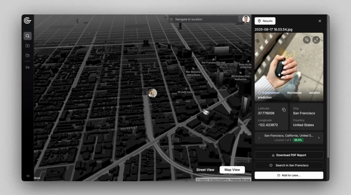
It seems like there is a company selling such a ‘good enough’ service.
I’ve seen those speed run videos where they basically go, ah yes this pebble is upper Midwestern Peruvian, and then get the location within 200 m.
Not gonna lie, I’d like to use this geotag a bunch of photos that I dont have location tagged to it.
NO CITIZEN BENEFIT! SURVEILLANCE USE ONLY!
Would be funny if it’s just an API call to OpenAI in the backend
Funnier if it just funneled all requests to the GeoGuessr dude.
“Do you funnel all requests to the GeoGuessr dude?”
“No.”
“Be a lot cooler if you did.”
human-as-a-service
Not too far off of how a lot of AIs function, unfortunately
He went to school in Flippin, Arkansa
The US has some while place names. Then they get bored and ruin it and just call it New [already famous place]
We need to poison the well. Start uploading pics with incorrect metadata. Stonehenge is now in Alaska. Rocky desert land in Madagascar.
I have a shortcut that strips exif data. I use it if I’m sending or posting pics.
Quite a lot of the commercially available AIs can already do this. I uploaded a picture I took with no metadata attached to it and it was able to correctly identify the location. Reverse image search completely failed but that’s understandable since it’s my photograph.