As funny as that is, something tells me it’s not that hard to spot an aircraft carrier in the Mediterranean
You have to be in visual range, or radar range if you have one, which is the horizon plus a bit more depending how high above sea level your are and how tall your target is.
If you’re on a ship, unless you’re using an advanced radar that bounces signals against the ionosphere or you have a meteorological phenomena called an inversion which can curve your radar energy over the horizon a little bit, your radar horizon is surprisingly short, something around 12 nautical miles give or take. And the sea is big and Iran is quite far.
This is one big reason why aircraft are used for surveillance at sea. They can go much higher than any ship’s radar antenna mast every could be which significantly expands their radar horizon. They can also scan a huge area relatively quickly as they can travel much faster.
Because if this fuck up, Iran now has the intel that the French carrier is approaching without even having to send an aircraft out to look for it. If they even still have the ability to do so at this point.
why don’t ships at sea simply disguise themselves as a rock or shrubbery?
Or as a duck if they need to move.
BTW sweden have some cool ship disguises.
Edit: went looking for it, couldn’t even find a photo.
Yeah, that’s how good they are.
Found an old, not very effective but fun one:

The Swedish Navy’s ships do have some bonkers designs, like massive barcodes printed on the side. It’s so that when they get back to port they can scan the navy in.
(‘scandinavian’ for people like me)
China and Russia could also just tell Iran, if they don’t have satellites of their own
Because if this fuck up, Iran now has the intel that the French carrier is approaching without even having to send an aircraft out to look for it.
It wasn’t exactly a secret, France publicly announced it was being moved to the eastern med
I saw the location on one of those “war dashboards” a day or two ago. Can’t have been that secret.
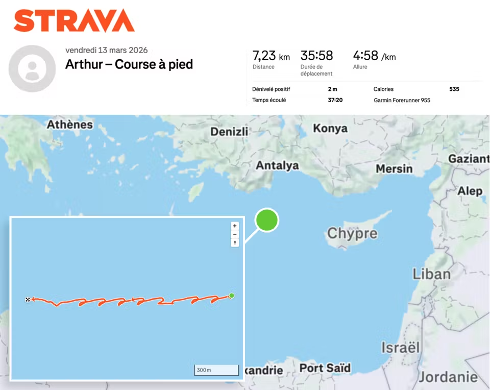
Apparently strava is for posting your runs on social
That sailor now got the runs
Imagine losing a carrier cuz one of the soldiers forgot to read the privacy notice on their smartwatch
Why does it look exactly like my signature!?
OsmAnd ftw
Why is it zig zagging?
that’s how it looks when you walk/run in circles in a vessel that’s moving
Wow. Can you infer vessel speed by assuming the run always concluded at the start position? The bottom line doesn’t meet back at the top line because the ship and runner were going in opposite directions.
You don’t need that assumption. Your assumption can just be “the person and vessel (or a point in the vessel, like its center of mass) don’t diverge significantly over time”.
Then, if you treat velocity as a vector and compute the person’s average velocity vector over time, you’ll have a pretty close estimation to the vessel’s velocity vector.
After all, if those two average vectors (vessel’s and person’s) were to differ much, they would end up in different locations.
The average basically zeroes the vector for each lap the person does, so the remainder must be the vessel’s.
Wow. Can you infer vessel speed by assuming the run always concluded at the start position? The bottom line doesn’t meet back at the top line because the ship and runner were going in opposite directions.
It’s not like an aircraft carrier is hard to detect anyways. And I doubt you can register Strava activities in a submarine.
Also also, it’s not because there hasn’t been a 2nd snowden that there aren’t modern Pegasus.
Why is it making loops? To see if it is being followed by Sean Connery?

Nope, at least according to AI
What you’re seeing A mostly straight transit line With repeating small loops / hooks along the way Consistent spacing and direction 👉 That pattern = cyclic flight operations while underway ✈️ What the Charles de Gaulle is likely doing Each “loop” is a mini sequence like this: Turn into the wind Carrier adjusts heading to maximize wind over deck Needed for launching/recovering aircraft (especially Rafale M) Launch or recover aircraft Catapult launches or arrested landings happen during this leg Ship holds a steady heading for safety Turn back to original course After the cycle, it resumes its transit direction Then repeats the process for the next wave 🔁 Why the pattern repeats like that Carriers operate in cycles (called “cycles” or “events”): Launch a group of aircraft Recover them later Launch again Each cycle = one of those little loops you see. The regular spacing suggests: Well-planned air wing operations Likely training or sustained mission ops, not evasive action 🧠 Key insight (what makes this clearly flight ops) This is not random zig-zagging because: The turns are uniform and rhythmic Always return to the same general heading No large erratic deviations 👉 That’s classic “wind-over-deck corrections during air ops” ⚠️ Bonus detail (specific to Charles de Gaulle) Unlike US carriers, the French carrier uses CATOBAR with shorter deck and heavier jets, so: It’s even more sensitive to wind conditions Requires frequent heading adjustments Which makes these looping patterns very visible on tracking maps Bottom line That track is essentially a breadcrumb trail of aircraft launches and recoveries. If you count the loops, you can roughly estimate how many flight cycles happened during that transit. If you want, I can break down how many aircraft were likely launched per loop and what type of mission profile that suggests (training vs combat readiness vs transit ops).